Who's to blame for DISINFORMATION?
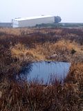
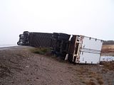
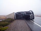
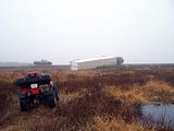
Wind gusts at the Wreckhouse reached 111 kph Wednesday around 6:30 pm and this rig was the latest casualty . The driver of the Rig was taken to the hospital. I have written quite a few posts over the years on my Blog about the accidents and the need for better signage. Part of the problem involves the weather announcers on Radio and Television who keep refering to the Wreckhouse as being in the Bay of St. Georges area when in fact it's well over a hundred kilometers from St. Georges. I wonder how many accidents are caused by such weather announcements when unsuspecting tourists hauling campers/trailers and truckers new to the island hit the winds just 15 minutes off the Gulf Ferry and expecting the Wreckhouse to be a hundred kilometers or more away? Maybe someone involved in an accident should take it on themselves to sue the Government of NL for damages sustained in an accident such as the one in the photo. We need better signage and a bit of Geography taught to the weather people who put the disinformation out over the airwaves.
Few shots of the recent one.


9 comments:
i always found that foolish when they mention the wreckhouse in st georges.i wonder how the people in st georges react to hearing it?
i like the photo effect you have created in this one.we hear a bit about the area on the weather channel and you should be sending a few photos and a story or two there.
s.d.
I must say I always thought Wreck House was further up the coast too, not sure why I had that perception but I did.
Since the government does not have any concern for peoples safety maybe a business in the area could help by putting up a warning sign along with some adds for their business. That should get around the provincial road signs buearocratic mumbo jumbo; it helps the public and helps the business.
the wreckhouse is just a few kilometers from cape ray and just 20 kilometers outside of port aux basques. when tourists or unsuspecting truckers who are newbies to the area listen to a forecast they are led to believe they are safe until they reach the st. georges area. someone will die one day and the signs will go up after that. that's the way our government works here.
Wreckhouse IS contained in the meteorological service forecast area called St. George's.
Map of Forecast RegionsA Wreckhouse Wind warning for "St. George's" is entirely accurate.
WJM,tell that to the unsuspecting motorists that blows off the road 15 minutes after he leaves the ferry in port aux basques. they think they're safe until they get near st. georges. it's misinformation!
How is it misinformation?
Wreckhouse winds are forecast for the St. George's forecast area. And 15 minutes after you leave the ferry in PAB, you're in the St. George's forecast area.
What's misleading? Caveat driver.
take a look at a map and actually tell those of us who live here that wreckhouse is in the bay st. georges area.
we have had accidents here simply because unsuspecting motorists do not expect to be in high winds until they are at least 130 plus kilometers away from the ferry,not 20 kilometers. mis-information and someday some one will die because of it.
i doubt if i will shoot that photo.
we are tourists coming to newfoundland, having no idea about wreckhouse winds, we came from Port aux Basques, no warning signs on the highway, we left 8am this morning, 20 minutes later our coach is nearly blown off the road, another RV lying in the ditch in the opposite lane...
why don't they warn motorists, especially people who have no ideas about this area... weird, do you want to gain notority that way?
Post a Comment